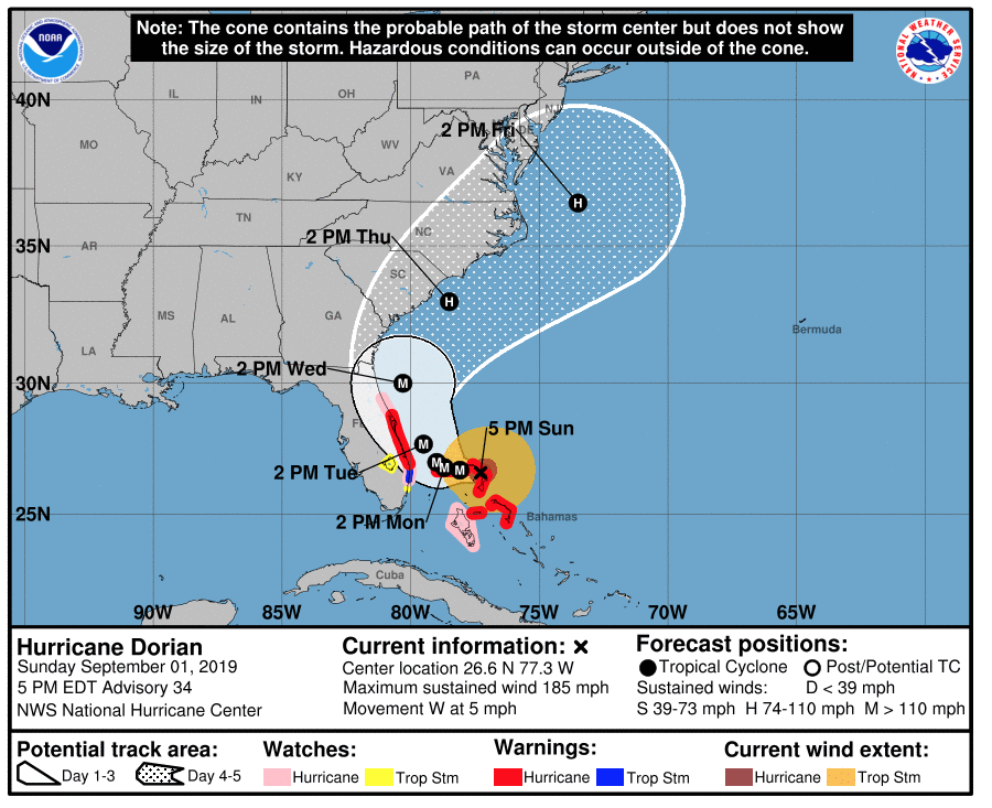
BOCA RATON, FL (BocaNewsNow.com) — The 5pm Sunday (September 1, 2019) update from the National Hurricane Center brings massive Dorian “dangerously close to the Florida coast.”
From the NHC:
Hurricane Dorian Discussion Number 34 NWS National Hurricane Center Miami FL AL052019 500 PM EDT Sun Sep 01 2019 The distinct eye of powerful Hurricane Dorian is moving over Great Abaco. The latest wind and pressure data from an Air Force reconnaissance plane just before the eye hit the island indicated that the winds reached 160 kt, which is the initial intensity for this advisory. It is not very often that we measure such strong winds. The minimum pressure measured by the plane was 910 mb. The eye has been shrinking, and an eyewall replacement cycle is possibly occurring. The effect of the island terrain and the eyewall replacement cycle should result in some slight fluctuations in intensity during the next 24 to 36 hours, but the hurricane will continue to be extremely dangerous one during that time. After 3 days, a more definite weakening trend should begin as the hurricane encounters stronger shear. Dorian however, it is forecast to remain a hurricane for the next 5 days. Dorian has slowed down even more and is now moving toward the west or 270 degrees at 4 kt. The steering currents are collapsing and Dorian is expected to slow down a little more, prolonging its catastrophic effects in the northwestern Bahamas. The NHC forecast calls for a slow west to west-northwest motion during the next 48 hours. A turn to the north and northeast with a gradual increase in forward speed is expected thereafter, as the mid-level trough over the eastern United States deepens. The current forecast is not very different from the previous one, and it is very close to the multi-model consensus TVCA. Both the deterministic and consensus tracks have shown the usual variability to the right or to the left from run to run, but the overall trend is for the hurricane to turn northward offshore but dangerously close to the Florida peninsula. Given the uncertainty in the track forecast and the anticipated increase in size of the hurricane, a Hurricane Warning and Storm Surge Warning have been issued for a portion of the Florida east coast. It is once again emphasized that although the official track forecast does not show landfall, users should not focus on the exact track. A small deviation to the left of the track could bring the intense core of the hurricane its dangerous winds closer to or onto the Florida coast. Key Messages: 1. A prolonged period of catastrophic winds and storm surge will affect the Abaco Islands and Grand Bahama Island tonight. Everyone there should take immediate shelter and not venture into the eye. 2. Life-threatening storm surge and dangerous hurricane-force winds are expected along portions of the Florida east coast through mid-week, and storm surge and hurricane warnings are in effect. Only a slight deviation to the left of the official forecast would bring the core of Dorian near or over the Florida east coast. Residents should listen to advice given by local emergency officials. 3. There is an increasing likelihood of strong winds and dangerous storm surge along the coasts of Georgia, South Carolina, North Carolina later this week. Residents in these areas should continue to monitor the progress of Dorian and listen to advice given by local emergency officials. 4. Heavy rains, capable of producing life-threatening flash floods, are expected over northern portions of the Bahamas and coastal sections of the southeast and lower mid-Atlantic regions of the United States through late this week. FORECAST POSITIONS AND MAX WINDS INIT 01/2100Z 26.6N 77.3W 160 KT 185 MPH 12H 02/0600Z 26.7N 78.1W 155 KT 180 MPH 24H 02/1800Z 26.8N 78.7W 145 KT 165 MPH 36H 03/0600Z 27.0N 79.0W 135 KT 155 MPH 48H 03/1800Z 27.7N 79.5W 125 KT 145 MPH 72H 04/1800Z 30.0N 80.3W 105 KT 120 MPH 96H 05/1800Z 33.0N 78.5W 90 KT 105 MPH 120H 06/1800Z 36.5N 73.5W 80 KT 90 MPH
