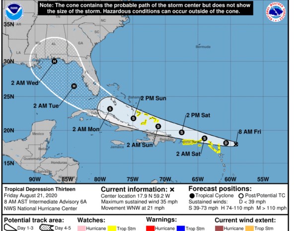
BOCA RATON, DELRAY BEACH, BOYNTON BEACH, PALM BEACH COUNTY IN CURRENT PATH.

BOCA RATON, FL (BocaNewsNow.com) — The National Hurricane Center has just elevated Tropical Depression “13” to Tropical Storm Laura. The storm is on a path that currently brings it to — or extremely close to — South Florida Monday afternoon or evening.
The cone, however, can change dramatically in the span of several hours. Right now, the key is watching. If the present track holds, the forecast as of Friday morning calls for the storm’s winds to reach the South Florida peninsula Monday. Laura could hit as a strong tropical storm or weak hurricane. We stress it is still early, but this is certainly a good time to finalize a hurricane plan while purchasing any supplies that you may need. It is unlikely this storm will lead to mass evacuations, but keep an eye on the forecast.

Here is the latest from the National Hurricane Center:
Tropical Storm Laura Tropical Cyclone Update
NWS National Hurricane Center Miami FL       AL132020
905 AM AST Fri Aug 21 2020

...NOAA HURRICANE HUNTER AIRCRAFT FINDS THAT THE DEPRESSION HAS
STRENGTHENED TO TROPICAL STORM LAURA...

Data from a NOAA Hurricane Hunter aircraft indicate that Tropical
Depression Thirteen has strengthened and is now Tropical Storm
Laura with maximum sustained winds of around 45 mph (75 km/h). The
aircraft also found that the center of Laura is located south of the
previously estimated position. These changes will be reflected in
the track and intensity forecasts with the upcoming advisory that
will be issued at 1100 AM AST (1500 UTC).


SUMMARY OF 905 AM AST...1305 UTC...INFORMATION
---------------------------------------------------
LOCATION...17.0N 59.8W
ABOUT 230 MI...375 KM ESE OF THE NORTHERN LEEWARD ISLANDS
MAXIMUM SUSTAINED WINDS...45 MPH...75 KM/H
PRESENT MOVEMENT...W OR 280 DEGREES AT 21 MPH...33 KM/H
MINIMUM CENTRAL PRESSURE...1008 MB...29.77 INCHES

$$
Forecaster Brennan/Pasch
