Atlantic Hurricane Season Continues Through November.

BY: STAFF REPORT | BocaNewsNow.com
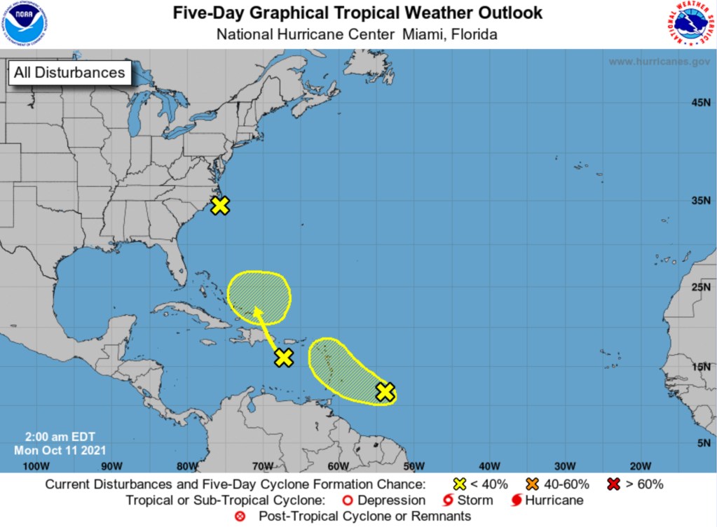
BOCA RATON, FL (BocaNewsNow.com) (Copyright © 2021 MetroDesk Media, LLC) — The National Hurricane Center is watching two new tropical waves with the potential to form southeast of Florida.
Any interaction with the United States mainland — if there is in any interaction — is several days away. The waves, for now, have reduced chances of development over the next several days.
The waves are represented by the yellow “x” above. The ovals, which are also represented on the map, indicate where a tropical system may form — not necessarily a direction of travel.
This is the early morning outlook from the National Hurricane Center for Monday, October 11th, 2021.
For the North Atlantic...Caribbean Sea and the Gulf of Mexico:

1. A non-tropical low pressure area located just off the North
Carolina coast continues to produce some disorganized showers and
thunderstorms.  Although this system is not expected to become a
tropical or subtropical cyclone, locally heavy rainfall and gusty
winds are still possible over portions of the North Carolina Outer
Banks today and information on these hazards can be found in
products issued by your local National Weather Service Office.
Additional information on this low pressure system, including gale
warnings, can be found in High Seas Forecasts issued by the National
Weather Service.
* Formation chance through 48 hours...low...near 0 percent.
* Formation chance through 5 days...low...near 0 percent.

2. A tropical wave located about 400 miles east-southeast of the
Windward Islands continues to produce disorganized cloudiness and
thunderstorms.  Some slow development is possible during the next
day or two while the system moves west-northwestward at about 15 mph
toward the Lesser Antilles.  After that time, strong upper-level
winds are expected to limit further development.  Regardless of
development, the system could produce locally heavy rainfall and
gusty winds across portions of the central and northern Lesser
Antilles on Tuesday, and across the Virgin Islands and Leeward
Islands on Wednesday.
* Formation chance through 48 hours...low...20 percent.
* Formation chance through 5 days...low...30 percent.

3. Another tropical wave located over the eastern Caribbean Sea is
producing a large area of disorganized cloudiness and showers.
Unfavorable upper-level winds are expected to limit development
over the next day or so, but environmental conditions could become a
little more conducive for some gradual development of the system
when it is located near the southeastern Bahamas around midweek.
Regardless of development, locally heavy rainfall is possible over
portions of the Lesser Antilles, Puerto Rico, and Hispaniola during
the next couple of days.
* Formation chance through 48 hours...low...10 percent.
* Formation chance through 5 days...low...20 percent.

High Seas Forecasts issued by the National Weather Service can be
found under AWIPS header NFDHSFAT1, WMO header FZNT01 KWBC, and
online at ocean.weather.gov/shtml/NFDHSFAT1.php

