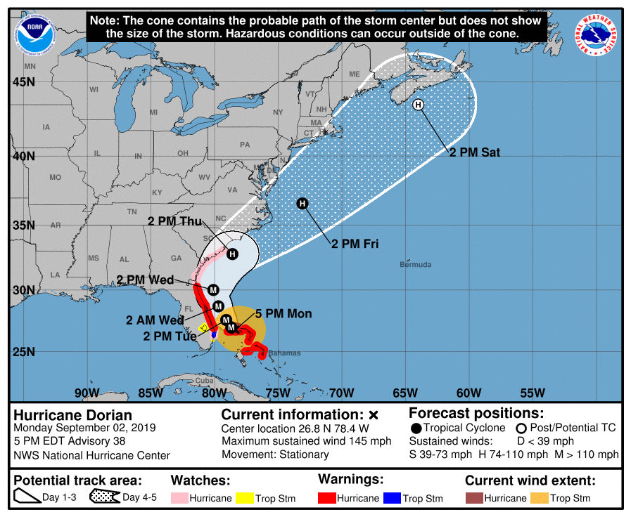
BOCA RATON, FL (BocaNewsNow.com) — We’re not done yet. The 5pm update from the National Hurricane Center says the turn ‘should’ start tomorrow (Tuesday) but that the storm will come ‘precariously close’ to the coast. To put it another way: this hasn’t even started yet, and you’d be a fool to let your guard down at this point.
From the NHC at 5pm (September 2, 2019) —
Hurricane Dorian Discussion Number 38 NWS National Hurricane Center Miami FL AL052019 500 PM EDT Mon Sep 02 2019Dorian remains an impressive hurricane in satellite imagery. Recent radar and aircraft observations are again showing signs of a concentric eyewall structure which might be one of the factors that has led to a decrease in the peak winds and a small expansion of the wind field.
An Air Force Reserve Hurricane Hunter aircraft reported peak flight-level winds of 129 kt, SFMR winds of 121 kt, and a central pressure that has risen to 940 mb. Based on these observations, the initial wind speed has been set at 125 kt. Some additional decrease in wind speed is likely in the short term due due to a possible eyewall replacement and upwelling of cooler waters caused by the very slow motion of the hurricane. Although some additional slow weakening is forecast while the hurricane moves northward along the southeastern United States coastline due to increasing southwesterly shear, Dorian is forecast to remain a powerful hurricane during that time. The NHC intensity forecast forecast is a blend of the latest statistical and and consensus model guidance.
Dorian has become nearly stationary this afternoon with the two most recent aircraft fixes showing essentially no motion. A slow westward to west-northwestward motion should resume overnight and continue into early Tuesday, with the eye and devastating winds only slowly pulling away from Grand Bahama Island. By Tuesday afternoon, Dorian should begin its much anticipated northwestward turn as a weakness becomes more pronounced in the subtropical ridge.
Although the center of Dorian is forecast to move near, but parallel to, the Florida east coast, only a small deviation of the track toward the west would bring the core of the hurricane onshore. A broad mid- latitude trough should help turn Dorian northeastward by Wednesday night, and the track models show the center coming precariously close to the southeastern United States coast. The tracks from the 1200 UTC runs of the global models have remained fairly stable, which has resulted in little overall change to the latest NHC track forecast.
Users are reminded that the hurricane is not a point, and that life-threatening storm surge and hurricane-force winds extend far from the center. Regardless of the exact forecast track, strong winds and a life-threatening storm surge are likely along a portion of the U.S east coast from Florida through the Carolinas.
Key Messages:
1. Devastating winds and storm surge will continue to affect Grand Bahama Island through tonight. Everyone there should remain in shelter and not venture into the eye.
2. Life-threatening storm surge and dangerous hurricane-force winds are expected along portions of the Florida east coast and the coasts of Georgia and South Carolina, regardless of the exact track of Dorian’s center. Water levels could begin to rise well in advance of the arrival of strong winds. Residents in these areas should follow advice given by local emergency officials.
3. The risk of life-threatening storm surge and hurricane-force winds continues to increase along the coast North Carolina. Residents in these areas should follow advice given by local emergency officials.
4. Heavy rains, capable of producing life-threatening flash floods, are expected over northern portions of the Bahamas and coastal sections of the southeast and lower mid-Atlantic regions of the United States through Friday.

