BY: WEATHER TEAM | BocaNewsNow.com
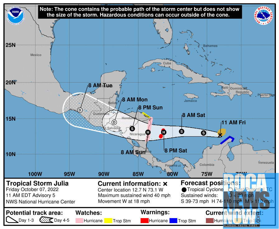
BOCA RATON, FL (BocaNewsNow.com) (Copyright © 2022 MetroDesk Media, LLC) — Tropical Storm Julia is now an active system being monitored by the National Hurricane Center. Watches and warnings are in effect.
Here is the mid-day Friday update from the NHC:
Tropical Storm Julia Discussion Number 5 NWS National Hurricane Center Miami FL AL132022 1100 AM EDT Fri Oct 07 2022
Earlier this morning, a concentrated burst of deep convection with a high density of lightning developed near the center of the cyclone while it was over the Guajira Peninsula, and microwave imagery shows that convective banding has increased somewhat over the adjacent waters. An Air Force Reserve Hurricane Hunter aircraft currently investigating the system so far has found maximum 925-mb flight-level winds of 47 kt and SFMR surface winds of 34 kt, and on that basis, the depression is upgraded to a 35-kt tropical storm.
Based on the latest aircraft fix, Julia is moving a bit faster toward the west than expected with an initial motion of 280/16 kt. A strong east-northeast to west-southwest oriented ridge which stretches into the southern Gulf of Mexico should keep Julia on a quick westward path during the next 48 hours. Since the track guidance has sped up a bit over the past few forecast cycles, the official forecast now brings Julia to the coast of Nicaragua by Sunday morning, which is a little sooner than was previously forecast. After landfall, the track guidance currently indicates that Julia and its remnants should remain over Central America and southern Mexico through Tuesday.
Stiff north-northwesterly shear (15-20 kt) is affecting Julia, and that can be seen in the suppression of the northern edge of the recent convective burst. Shear diagnostics suggest that this shear should abate soon, and Julia should commence a steady strengthening trend during the next two days while it crosses the southwestern Caribbean Sea. Julia is forecast to become a hurricane by Saturday evening, and the forecast peak intensity at the time of landfall in Nicaragua is unchanged from the previous advisory. The official forecast at that time is a bit above HCCA and the IVCN consensus aids, but it’s still below SHIPS and LGEM guidance. The NHC forecast shows 72- and 96-hour remnant low points to indicate the expected track over Central America, but it is highly likely that the center will have dissipated by those times.
Key Messages:
- Julia is forecast to strengthen into a hurricane by Saturday evening while it moves over the southwestern Caribbean Sea, and a Hurricane Warning is now in effect for San Andres, Providencia, and Santa Catalina Islands. A Hurricane Watch is also now in effect for much of the Nicaragua coast. Hurricane-force winds and a dangerous storm surge are expected in areas where the core of the system crosses the islands and moves onshore.
- The risk of flash flooding continues today over portions of the Guajira Peninsula. The potential for life-threatening flash flooding and mudslides is expected to spread to portions of Central America this weekend.
FORECAST POSITIONS AND MAX WINDS
INIT 07/1500Z 12.7N 73.1W 35 KT 40 MPH
12H 08/0000Z 13.0N 75.5W 45 KT 50 MPH
24H 08/1200Z 13.2N 78.7W 55 KT 65 MPH
36H 09/0000Z 13.1N 81.3W 65 KT 75 MPH
48H 09/1200Z 13.1N 83.6W 75 KT 85 MPH…INLAND
60H 10/0000Z 13.6N 85.9W 45 KT 50 MPH…INLAND
72H 10/1200Z 14.5N 88.5W 30 KT 35 MPH…POST-TROP/INLAND
96H 11/1200Z 16.2N 93.5W 25 KT 30 MPH…POST-TROP/INLAND
120H 12/1200Z…DISSIPATED

