Peak Hurricane Season Nears, Tropics Flaring Up

BY: STAFF REPORT | BocaNewsNow.com
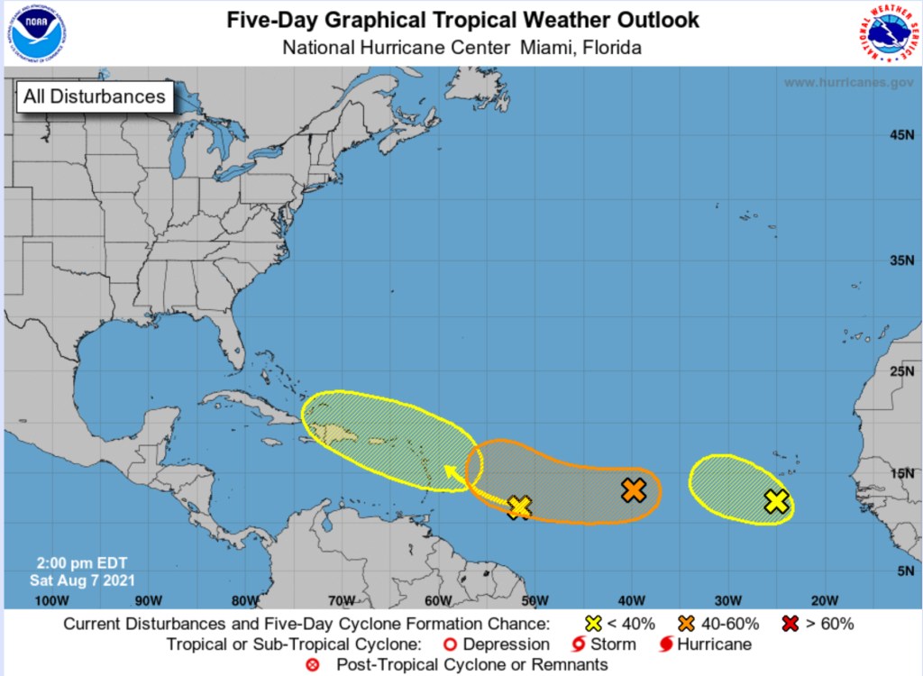
BOCA RATON, FL (BocaNewsNow.com) (Copyright © 2021 MetroDesk Media, LLC) — The latest update from Meteorologists at the National Hurricane Center suggests that it’s time to keep an eye on the tropics. Two of the three waves currently moving west appear to be heading in the general direction of Florida. We stress, however, that the ovals you see on the map above represent where a system may form, not necessarily a direction of travel.
This is the Saturday afternoon update from the National Hurricane Center:
For the North Atlantic…Caribbean Sea and the Gulf of Mexico:
- Showers and thunderstorms associated with a broad area of low
pressure located a little more than 100 miles south of the
southwesternmost Cabo Verde Islands have increased today. Some
gradual additional development is possible during the next day or
so but strong upper-level winds and cooler waters are likely to
prevent significant development after that time. The system is
expected to move generally west-northwestward to northwestward
across the eastern tropical Atlantic at 10 to 15 mph. Regardless
of development, locally heavy rainfall and gusty winds are
possible over portions of the southernmost Cabo Verde Islands
tonight and Sunday.
- Formation chance through 48 hours…low…30 percent.
- Formation chance through 5 days…low…30 percent.
- A small but well-defined area of low pressure located over the
tropical Atlantic about a thousand miles west of the Cabo Verde
Islands continues to produce limited shower activity. Environmental
conditions are expected to become a little more favorable for
gradual development over the next several days, and this system
could become a tropical depression by the middle of next week.
The system is forecast to drift toward the west-southwest or west
during the next couple of days, and then move a little faster
toward the west-northwest early next week.
- Formation chance through 48 hours…low…20 percent.
- Formation chance through 5 days…medium…40 percent.
- A tropical wave located over the west-central tropical Atlantic
is producing limited shower and thunderstorm activity. Significant
development of this system is not anticipated as it moves
west-northwestward across the Lesser Antilles and eastern Caribbean
Sea during the early to middle part of next week.
- Formation chance through 48 hours…low…near 0 percent.
- Formation chance through 5 days…low…10 percent.

